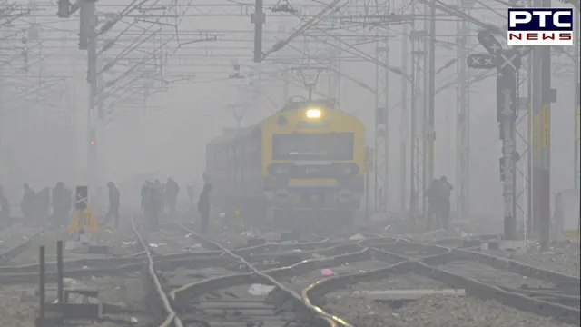

Delhi faces dense fog, 23 trains delayed; AQI reaches 'severe'
New Delhi, December 31: The India Meteorological Department (IMD) has indicated that North India, encompassing areas such as Delhi, Haryana, Punjab, and Uttarakhand, will continue to experience dense to very dense fog conditions until January 4, 2024. Simultaneously, certain regions in Kerala, Tamil Nadu, and Lakshadweep are expected to witness rainfall until January 3.
As of Sunday morning, moderate to dense fog persisted in several parts of North India, including Delhi, Haryana, and Uttar Pradesh. The IMD anticipates no relief from these weather conditions until the specified date.
/ptc-news/media/media_files/rbimrgVaQMGM8FUF99eC.webp)
Zero visibility was reported in Jorhat (Assam), Pathankot, and Bathinda (Punjab), Jammu (Jammu and Kashmir), and Agra (Uttar Pradesh). Additionally, visibility was recorded at 25 meters in Ambala (Haryana), 50 meters in Bikaner (Rajasthan), Patiala (Punjab), Chandigarh, Gwalior (Madhya Pradesh), and Jhansi (Uttar Pradesh). Amritsar (Punjab) and Hisar (Haryana) reported visibility at 200 meters, according to the weather department.
The prevailing coldwave conditions in North India have led to delayed train services due to poor visibility. At the Indira Gandhi International Airport in Delhi, visibility stood at 800 meters.
As commuters and travelers navigate through the challenging weather conditions, the authorities advise exercising caution and monitoring updates for any impact on transportation services.
Also Read: Govt's 2024 calendar showcases achievements with QR codes
Met Dept provides region-specific fog predictions and temperature trends
The India Meteorological Department (IMD) has released a comprehensive forecast, indicating the continuation of very dense fog conditions in various parts of North India. From December 31 to January 4, Punjab is expected to experience limited visibility (550 meters) during late evening to morning hours, while West Uttar Pradesh faces similar conditions during midnight and morning hours.
Additionally, Haryana, Chandigarh, Delhi, and East Uttar Pradesh are anticipated to encounter similar foggy conditions until January 1. Uttarakhand is predicted to witness dense fog with visibility ranging from 50 to 200 meters during the early morning hours from December 31 to January 4.
/ptc-news/media/media_files/spNdmLS6c07uk2Q909DX.webp)
Furthermore, the IMD forecasts comparable foggy scenarios in north Madhya Pradesh, north Rajasthan, and Jharkhand on December 31 and January 1; Gangetic West Bengal on December 31, and Odisha, Bihar, Assam, Meghalaya, Mizoram, and Tripura from December 31 to January 2.
The Met Department also notes the likelihood of cold day conditions in parts of Punjab, Haryana, and isolated pockets of Uttar Pradesh, Madhya Pradesh, and north Rajasthan until December 31. Meanwhile, a gradual temperature rise of 2-3°C is expected in many parts of Central India over the next two days, with significant changes thereafter.
Conversely, a decrease of 2-3°C in maximum temperatures is anticipated across many parts of Central and Northwest India in the next two days, while no significant changes in minimum temperatures are projected for the rest of the country.
Also Read: Don't come to Ram Temple on Jan 22, light diyas at home: PM Modi's appeal to devotees
IMD details forecasted precipitation patterns under the influence of western disturbance
Rainfall/Snowfall Forecast:
Under the subtle impact of a feeble western disturbance, the India Meteorological Department (IMD) has outlined projections for light isolated rainfall and snowfall across specific regions.
Jammu-Kashmir-Ladakh-Gilgit-Baltistan-Muzaffarabad; Himachal Pradesh and Uttarakhand (December 31):
On December 31 (Sunday), the IMD anticipates very likely occurrences of light isolated rainfall and snowfall in Jammu-Kashmir-Ladakh-Gilgit-Baltistan-Muzaffarabad, Himachal Pradesh, and Uttarakhand. These regions are expected to be influenced by the western disturbance.
Uttar Pradesh, Madhya Pradesh, and Chhattisgarh (January 1-3):
From January 1 to 3, the forecast predicts light isolated rainfall in Uttar Pradesh, Madhya Pradesh, and Chhattisgarh. The lower-level easterly winds originating from the Bay of Bengal are identified as the contributing factor for these anticipated weather conditions.
Also Read: Bajrang Punia calls for resumption of wrestling activities ahead of Paris Olympics
South India - Tamil Nadu, Kerala, and Lakshadweep (Till January 3):
In the southern parts of the country, specifically south Tamil Nadu, south Kerala, and Lakshadweep, the weather department foresees the likelihood of light to moderate rainfall in select areas until January 3 (Wednesday). These conditions are expected to prevail under specific meteorological influences.
This detailed insight from the IMD provides valuable information for residents and travelers, offering a glimpse into the expected precipitation patterns across different regions.
Also Read: Tragic blaze at Aurangabad gloves factory claims 6 lives
-
