Satellite images show ongoing construction of Chinese settlement near Pangong Lake amid border tensions
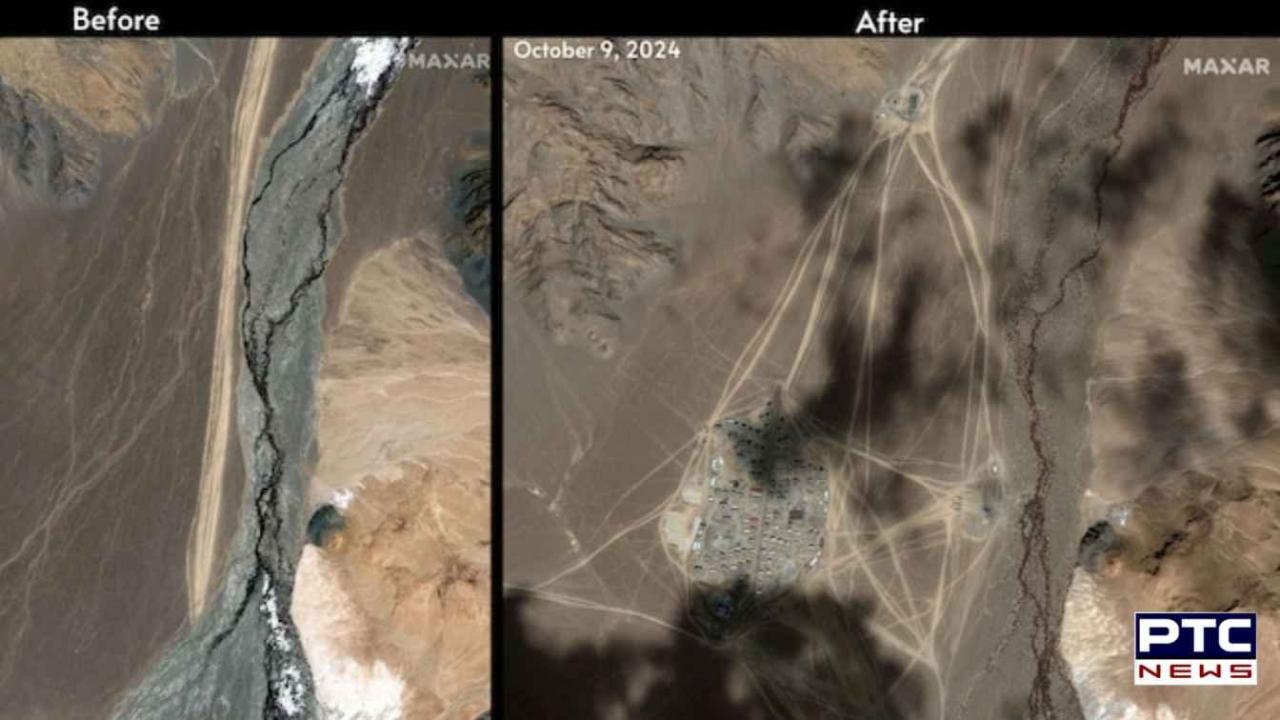
Satellite imagery obtained by India Today reveals extensive Chinese construction activity just 38 kilometers from the 2020 standoff site, sparking renewed concerns about China's growing border infrastructure.
PTC News Desk: As India and China continue diplomatic efforts to manage their strained relations along the disputed border, recent satellite imagery shown has revealed significant Chinese construction activity near the north bank of Pangong Tso Lake. The images suggest the construction of a large settlement, potentially signaling new developments in the ongoing border infrastructure buildup by China.
Chinese construction in Pangong Tso Lake
The newly discovered settlement is located approximately 38 kilometers east of one of the key standoff points from the 2020 India-China clashes. Though the settlement is outside the area claimed by India, its proximity to the sensitive region raises fresh concerns about China’s increasing presence near the Line of Actual Control (LAC).
Pangong Tso Lake, a vital geographical feature in the border dispute, is the highest saltwater lake in the world, straddling the India-China-administered border and extending into Tibet. This lake has been a flashpoint in the long-standing border tensions between the two countries.
Satellite imagery shows rapid development
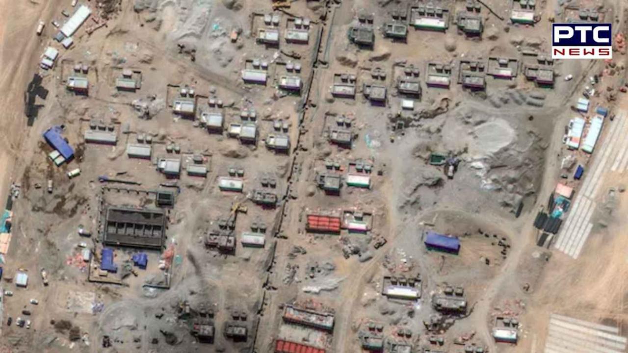
The satellite images, captured on October 9 by Maxar Technologies, reveal rapid construction activity spread over an area of approximately 17 hectares. The site, located near Yemagou Road at an altitude of 4,347 meters, shows extensive use of construction machinery and earth-moving equipment.
According to Y Nithiyanandam, Professor & Head of the Geospatial Research Programme at the Takshashila Institution, the area is being developed at a fast pace with more than 100 buildings under construction. These structures include both residential and administrative buildings, with additional open spaces that could be designated for parks or recreational facilities in the future.
One of the notable features of the site is a rectangular 150-meter-long strip in the southeast corner, which some experts speculate may be prepared for helicopter operations, adding to the settlement's strategic potential. The settlement appears to be divided into two sections, which may separate administrative zones from residential or operational areas.
Strategic and military implications
The location of the Chinese construction in Pangong Tso Lake gives it a strategic advantage, as it is nestled behind high peaks that shield the site from land-based surveillance. This feature makes it difficult for Indian or other observers to monitor the full scope of the development. Military experts have noted that the staggered layout of buildings, rather than traditional straight lines, may be designed to reduce vulnerability to long-range attacks.
If used for military purposes, the settlement could serve as an "ad-hoc forward base," enabling Chinese forces to reduce their reaction times in the event of a border escalation. This possibility adds another layer of complexity to India-China ties, as the two countries continue to engage in discussions to ease military tensions but have yet to reach a permanent resolution.
China’s resettlement of Tibetan nomads?
While the military significance of the site cannot be overlooked, some experts offer an alternative explanation for the construction. Nature Desai, an observer of the Indo-Tibetan frontier, suggests that the settlement could be designed to house Tibetan nomads. He identifies the location as Chanzun Nuru, a historic nomadic campsite mentioned in Swedish geographer Sven Hedin’s Central Asia Atlas.
According to Desai, the design of the settlement is more consistent with permanent housing developments built by the Chinese government for Tibetan nomads over the last two decades than with China’s Xiakong-style border defense villages.
If Desai’s assessment is correct, this would mark the first such settlement of Tibetan nomads in this particular area of Pangong Tso Lake. China has been actively resettling nomadic populations in Tibet for several years as part of its broader effort to establish permanent communities along the border region.
This initiative could be presented as a “gift” from Beijing to its loyal Tibetan nomads living along the sensitive frontier, further complicating the geopolitical situation.
Environmental and logistical challenges
Despite the rapid progress in construction, the settlement faces several challenges due to its high-altitude location. While the proximity to a water source near Pangong Tso Lake likely resolves water supply issues, the settlement’s energy needs are expected to rely on renewable sources such as solar power.
The extreme weather conditions in the region, especially during winter, could slow down the completion timeline for the settlement.
Nevertheless, experts believe that residential structures are already near completion, with significant progress made in the last six months. As diplomatic efforts to ease India-China tensions continue, the development of this settlement underscores China’s ongoing push to enhance its border infrastructure, raising further concerns about future India-China clashes and the broader impact on India-China ties.
The discovery of the new Chinese construction in Pangong Tso Lake comes at a sensitive time in India-China relations. With the rapid construction of over 100 buildings in a strategically important region, the settlement reflects China’s growing focus on strengthening its border infrastructure.
Whether the site is intended for military purposes or as a settlement for Tibetan nomads, it adds to the already complex dynamics of India-China tensions, highlighting the ongoing challenges in achieving long-term peace and stability along their disputed border.